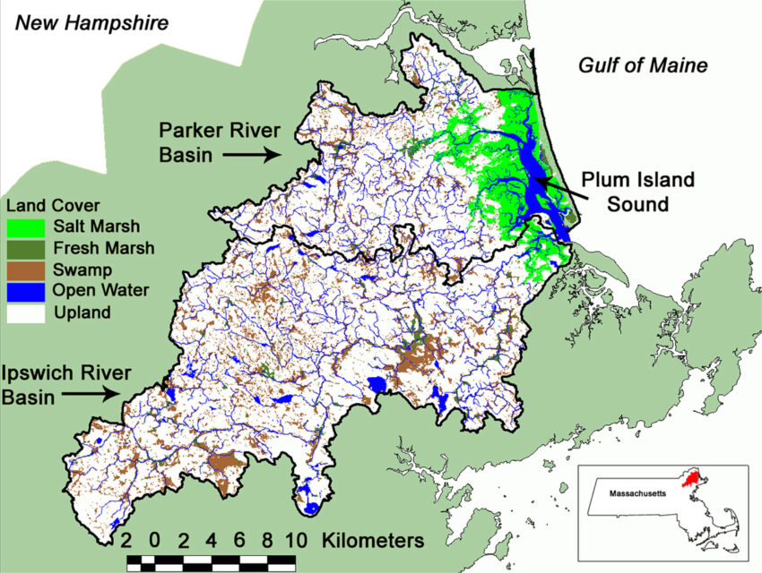
Our research site consists of coupled watersheds and estuaries in Plum Island Sound.
Plum Island Sound lies within the Boston Metropolitan region in northeastern Massachusetts, with a population density of about 250 people per km2. The Plum Island Sound estuary is a 25 km long (16 mile) macrotidal, coastal, bar-built estuary containing extensive areas of productive tidal salt marshes dominated by marsh hay (Spartina patens) and smooth cordgrass (Spartina alterniflora), fresh marsh dominated by cattail (Typha), intertidal flats, and open water tidal creeks and bays. The brackish and saline tidal wetlands of the site form a major portion of the Great Marsh, the largest contiguous intact marsh on the northeast coast of the United States. The marshes and estuarine waters are influenced by three rivers: the Ipswich, the Parker, and the Rowley, which collectively drain over 550 km2 of upland. The system is macrotidal with a tidal range often exceeding 3 meters.
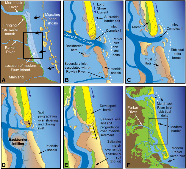
The marshes of Plum Island Sound formed approximately 3 thousand years ago from a paraglacial environment (Hein et al. 2012). Plum Island Sound lies within the Acadian biogeographic province; a cold-water environment sharing many species with boreal and Arctic provinces of the western Atlantic Ocean. It is located 150 km north of Cape Cod, Massachusetts, which is the historical geographic boundary for many southern aquatic species. Shallow soils, glacial till, and bedrock outcrops are dominant geological features formed during the last ice age. Geology of the basin is primarily igneous and metasedimentary Paleozoic and Precambrian bedrock with surficial deposits of till, gravel, and sand. Wetlands underlaid by glaciofluvial deposits are the largest natural water storage areas of the basin. The basin has a northern temperate climate with 1,180 mm of precipitation evenly distributed throughout the year. Air temperature fluctuates annually between an average winter minimum of -7ºC and an average summer maximum of about 28ºC. The average growing season is 180 days between mid-April and mid-October. River flow is greatest during early spring snowmelt and low in the summer and fall when evapotranspiration and municipal water withdrawals exceed rainfall. Because diversion of river water for sewage and municipal water needs exceeds river flow in summer (>20% of annual flow), mid reaches of the river often dry up. The Ipswich River has been designated one of the 10 most threatened rivers in the country (AmericanRivers, 2003).
Plum Island Sound been a source of economic productivity for more than 200 years. The estuary supports extremely productive commercial and recreational soft-shell clam and striped bass fisheries and is an important migratory bird resting and feeding ground. New England marshes were also managed for centuries for the production of salt marsh hay (Spartina patens). Management included extensive ditching, channel alteration, control structures, and low elevations berms. Additional extensive ditching was done in the 1930s for mosquito control. In the last few decades, many of these heavily managed areas have seen peat subsidence, waterlogging, and conversion of high marsh to low elevation marsh. To counter this, and to preserve high marsh habitat for the endangered salt marsh sparrow, several small experimental restoration efforts are underway, and if successful, restoration activities may commence on over 2,000 acres. Conditions in Plum Island Sound are now changing due to the rapidly warming waters of the Gulf of Maine and we have seen the expansion of several species of southern species into PIE marshes.
Local land use has changed substantially since European colonization. Human population has increased dramatically over the past 50 years, and was estimated at about 470,000 in 2000 (328 people/km, U.S.Census, 2006). In the past two decades, land-use change has been more widespread in the Boston area (433,000 acres) than any other Metropolitan Statistical Area (MSA) in the country except Atlanta. This growth in land area has been accompanied by one of the smallest increases in population (12%). As a result, the Boston MSA, which includes our study area, has become one of the most “sprawling” areas in the country. This development pattern is being driven by persistently high home prices, which are driving low- and middle-income residents to outlying areas; by high-income residents who are developing coastal areas for seasonal recreational use; and by a fragmented decision-making landscape where the land-use decisions in one town directly affect the development pressures and outcomes in neighboring towns.
Research History
We have been investigating the ecology of Plum Island Sound estuary since the late 1980s with support primarily from the National Science Foundation (NSF). We were part of NSF Land Margin Ecosystems Research program in the early 90s. The site became part of the NSF's Long Term Ecological Research (LTER) Network in 1998. The Plum Island project is one of only four LTER sites that studies the effects of human activities in watersheds on estuaries.
Estuaries are among the most productive ecosystems on Earth. Their location at the land-sea interface, where growth-stimulating inputs from river runoff mix with ocean tides, contributes to a broad diversity of primary producers and some of the most productive fisheries in the world. But estuaries are also increasingly threatened by a variety of natural phenomena (climate variability, sea level rise) and human actions (nitrogen pollution, freshwater withdrawal, sediment erosion, overfishing).
Our research sheds light on the controls on marsh accretion and loss, blue carbon storage, the exchange of carbon and nutrients, and how food webs are changing with SLR, warming, and ecosystem responses. Some of our long-term monitoring activities include two continuous weather stations collecting meteorological data, continuous sea level measurements, two eddy flux stations, and yearly measurements of primary productivity, organic matter, inorganic nutrients, and population studies. Other research projects have focused on the interactions of changing nutrient, water, and organic matter inputs and the impact of external drivers and human activities have shaped ecological processes within the estuary. Current research is designed to better understand how land use change, sea level rise, climate, and geomorphology impacts the estuary.
The Plum Island Ecosystems LTER has developed an extensive database open to the public that includes our results from long-term field observations and experiments in the Ipswich, Parker and Rowley River watersheds and the Plum Island Sound estuary.


